


A cold front, coupled with the approaching new typhoon, is set to impact Guangzhou's weather in the coming days.

Affected by a weak cold front, Guangzhou has experienced a slight drop in temperature. Yesterday morning, except for the northern part of Conghua, most areas of Guangzhou recorded temperatures slightly above 20°C, providing a cool and comfortable sensation.
According to Guangzhou's weather forecast, the city will enjoy sunny weather for the next three days, with an increase in the diurnal temperature range. The lowest temperatures are expected to occur on the mornings of the 7th and 8th, dropping to as low as 17°C. From the 9th onwards, temperatures will gradually rise. However, starting from the 10th, Typhoon "Yinxing" is expected to bring an increase in cloud cover.
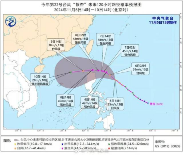
Typhoon "Yinxing," the 22nd typhoon of the year, intensified into a Category 14 severe typhoon last night, according to the National Meteorological Center. As of 5 a.m. yesterday (November 6), it was located approximately 560 kilometers northeast of Manila, the Philippines, with maximum sustained winds near the center reaching 140 kilometers per hour (42 meters per second), and a minimum central pressure of 955 hectopascals.
The typhoon's wind field is vast, with a radius of 160-200 kilometers for gale-force winds (winds with speeds of 17.2-32.6 meters per second), 80-120 kilometers for very strong winds (winds with speeds of 24.5-36.9 meters per second), and 50-70 kilometers for hurricane-force winds (winds with speeds exceeding 32.6 meters per second).
Currently, "Yinxing" is moving westward and may graze the northern part of the Philippines' Luzon Island. It is expected to enter the South China Sea between the night of the 8th and the morning of the 9th.
Since the beginning of this year's typhoon season, the number of typhoons landing in China has been unevenly distributed across months. July and September saw clusters of typhoons, with two landing in July and three in September. However, in August, traditionally a month of active typhoons, no typhoons made landfall in China despite six being generated in the Western Pacific and the South China Sea.
After "Yinxing," one to two more typhoons are expected to be generated in the Western Pacific within the next ten days. If this occurs, the number of typhoons generated in November this year will be close to or slightly more than the average.
Weather China reminds the public that autumn typhoons mostly follow a westward path and are most likely to make landfall in South China. This time, "Yinxing" is also likely to take a westward path and may bring strong winds and rain to coastal areas of South China from the late upper ten days to the early middle ten days of November. However, as the timing is still far off, it is recommended to closely monitor the typhoon's movement and nearby forecasts and be prepared for typhoon prevention measures.
Meanwhile, residents are advised to add clothing appropriately to prevent colds as temperatures gradually drop.
Author | Jiang Chang
Photo | Nanfang Plus
Editor | Liu Lingzhi, James, Shen He