


When examining the ecological map of Shenzhen, one cannot overlook the striking green mountain ridge stretching approximately 200 kilometers across the city. This iconic feature is none other than the Kunpeng Trail. Recently recognized as one of China's top 10 hiking destinations for 2024, the trail has swiftly become a hallmark of Shenzhen's natural beauty.
"Kunpeng" is derived from two mythical creatures — Kun, a colossal fish, and Peng, also known as the Roc, a magnificent bird. Together they embody the spirit of exploration and adventure.
Stretching from Feiyun Peak in Bao'an to Dayan Peak in Dapeng New Area, the Kunpeng Trail is Shenzhen's longest hiking trail. Spanning 20 segments, it connects 10 major mountains, approximately 20 country parks, a dozen reservoirs, cultural landmarks, over 30 urban landscapes, and nine key development zones.

The Kunpeng Trail No. 1 Bridge.
Along the way, hikers traverse lush forests, serene coastlines, and meandering rivers and lakes. The trail offers a unique way to admire Shenzhen's diverse landscapes while serving as a sanctuary for nearly 10,000 species of plants and wildlife.
According to the Shenzhen Municipal Urban Management Bureau, the principal government body behind the creation of the Kunpeng Trail, it was designed to cater to people with varying levels of outdoor experience. Each section is equipped with entry and exit points, allowing hikers to tailor their routes.
The western segments of the trail feature gentle terrain, ideal for individuals and families with young children. In contrast, the central stretch offers more intricate landscapes, challenging avid hikers, while the eastern portion traverses rugged mountains, requiring advanced outdoor expertise for a strenuous experience. The trail is marked every 500 meters with labels from YK000 to YK415, where "Y" stands for hiking and "K" for Kunpeng.
These hiking routes along the trail have been selected from a number of options following extensive field testing by individuals with varied outdoor skill levels, as previously reported in Chinese-language media.
Below, the trail is described segment by segment for those interested in exploring the city's natural landscapes.
Segment 1: Spanning from YK000 to YK012
This 6-kilometer stretch runs from Feiyun Peak of Fenghuang Mountain to Jiuwei Wetland Park in Bao'an District, taking about two to three hours to complete with a 196-meter ascent. The Wangyan Pavilion marks the halfway point, with stone steps defining the first half and dirt trails winding through dense woods in the second.

Fenghuang Mountain in Bao'an.
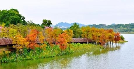
Jiuwei Wetland Park.
Segment 2: Spanning from YK013 to YK040
Stretching 11 kilometers from the Caihui Road entrance to Jiuwei Wetland Park, this segment takes about four to six hours to complete. The route heads south from Jiuwei along Zhoushi Road before turning east onto Yubei No. 8 Road. It passes through the Tiegang Reservoir section of the No. 2 Guangdong Provincial Greenway, Shuiku Road, Jiangang Mountain Boulevard, Guangtai Road, Shangchuan Road, and Baoshi Road. The segment ends at the Dajingshan Police Office on Baoshi Road, where it connects to Segment 3.
Segment 3: Spanning from YK041 to YK057
This 10-kilometer section stretches from Baoshi Road to the No. 2 Entrance in Makan Village, with a gentle elevation gain of just 21 meters, typically taking two to three hours to complete. The route, mostly passing through areas with slow urban traffic, offers hikers scenic natural views and a glimpse into the vibrant, leisurely life of urban villages.
Segment 4: Spanning from YK058 to YK073
This 7-kilometer stretch follows the ridge line of Yangtai Mountain Forest Park, offering natural beauty and an immersive outdoor experience. Taking about three to five hours to complete, the route features rugged dirt slopes, granite stone formations, and a massive stone elephant, enhancing the hike from the No. 2 mountain entrance in Makan Village to the Wangjingkeng Mountain entrance. Yangtai Mountain, the tallest peak in northwest Shenzhen at 587 meters, spans Bao'an, Nanshan, and Longhua districts. Hikers will pass boundary markers and enjoy multiple vantage points with expansive views.
Segment 5: Spanning from YK074 to YK093
This 10-kilometer section follows urban pedestrian paths and takes about two hours to complete, stretching from the Wangjingkeng Mountain entrance to Changlingpi Metro Station.
Segment 6: Spanning from YK094 to YK108
This 8-kilometer stretch, ideal for leisurely strolls and jogging, runs from Changlingpi Metro Station to Zijian Garden on Tanglang Mountain. It offers a pleasant two-hour walk through the city's slow traffic zones, with water features enhancing the experience.

A view of Tanglang Mountain.
Segment 7: Spanning from YK109 to YK124
This 8.5-kilometer section is part of Shenzhen's first Mountain-Sea Vista corridor, connecting Tanglang Mountain, Dasha River, and Shenzhen Bay Park. The route, which intertwines with several country trails, offers easy access from nearby subway stations. It takes approximately four to five hours to travel from Zijian Garden to the graffiti wall of the Meilin Reservoir Greenway in Futian District.
Segment 8: Spanning from YK125 to YK151
This 13-kilometer section, which moves along the ridges of Meilin and Yinhu mountains, offers sweeping views of mountains, lakes, and the city. With an elevation gain of 736 meters, some areas feature steep slopes requiring considerable physical effort. Most of the route consists of steep dirt paths, except for the stepped sections within Yinhu Mountain Country Park. The hike takes approximately six to eight hours, from the graffiti wall of the Meilin Reservoir Greenway to the Yinhu Mountain entrance at the Armed Police Hospital in Futian District.
Segment 9: Spanning from YK152 to YK169
Connecting six parks of various styles, this 11-kilometer section features both well-equipped parks, such as Honggang Park and Cuihu Cultural and Sports Park, as well as natural landscapes like Weiling Park and Buxin Hill Country Park. The route takes about four to five hours, from the Yinhu Mountain entrance at the Armed Police Hospital to Donghu Park.
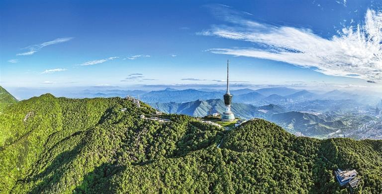
A view of the Shenzhen TV Tower on Wutong Mountain.

An aerial view of Wutong Mountain.
Segment 10: Spanning from YK170 to YK191
This 11-kilometer section primarily follows the Wutong Mountain Greenway, which is well signposted and equipped with supporting facilities, making it easy to navigate. The journey from Donghu Park to Wangtong New Road takes about four to five hours and is also suitable for cycling.
Segment 11: Spanning from YK192 to YK217
This 12-kilometer section stretches from Wangtong New Road to Tanxiangong Temple in Longgang District, taking hikers through forests and up mountain peaks. With an elevation gain of 1,200 meters, this physically demanding route crosses several peaks of Wutong Mountain, requiring strong fitness and endurance.
A view of Maluan Mountain.
Segment 12: Spanning from YK218 to YK252
This challenging 20-kilometer route spans from Tanxiangong Temple to the northwest entrance of Maluan Mountain Country Park in Pingshan District. Hikers will traverse multiple peaks, including Zhangding, Meisha, and Daguzhang, with a total elevation gain of 1,012 meters. The journey takes approximately six to 10 hours to complete.
Segment 13: Spanning from YK253 to YK272
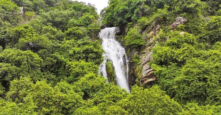
Starting at the northwest entrance to Maluan Mountain Country Park, this 10.5-kilometer route passes through trails such as Bilin Waterfall, Biling, Pingshan Forest, and Pingyan Plum-Viewing, ending at Luo Family's Estate. The first half of the route consists of dirt paths, while the latter part features greenways.
Segment 14: Spanning from YK273 to YK296
Starting at Luo Family's Estate, this section ascends from the north entrance of Maluan Mountain Country Park to Libi Mountain in Dapeng New Area. Hikers in good physical condition can combine Segments 13 and 14, completing the Maluan Mountain hike in a single excursion.
Segment 15: Spanning from YK297 to YK309
The first half of this 6.5-kilometer section winds through forests, gradually ascending to the peak of Libi Mountain. The descent is steep, requiring hikers to balance themselves by grasping nearby trees. The journey takes about three to four hours, ending at Kuichong Ecological Park.
Segment 16: Spanning from YK310 to YK339
This 12-kilometer section offers stunning views of blue seas, white sands, and lush greenery. The route from Kuichong Ecological Park to Jinsha Boulevard also passes several historical sites, including the Xiantouling Site and Dongjiang Column Evacuation Memorial Park. It takes approximately six to eight hours to complete.
Dongjiang Column Evacuation Memorial Park.
Segment 17: Spanning from YK340 to YK374
This 17-kilometer coastal stretch from Jinsha Boulevard to Egong Village offers breathtaking views of mountains and the sea. From the mountain peak, hikers can enjoy panoramic vistas of Daya Bay to the east and Dapeng Bay and Hong Kong's Peng Chau Island to the west. The hike takes about six to eight hours to complete.
Segment 18: Spanning from YK375 to YK394
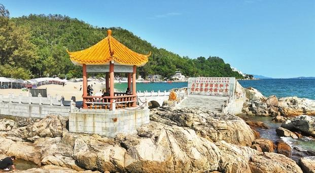
This moderate section begins with the Dalugang Trail, featuring a steeper descent in the first half. The second half traverses streets like Xigong Road, Nanxi Road, Heya Road, and Xinhai Road, with the beautiful Xichong Beach on the right. This segment can be explored on foot or by bike.

A bird's-eye view of the Shenzhen Astronomical Observatory and the Xichong Beach.
Segment 19: Spanning from YK395 to YK406
This 6-kilometer segment connects the stunning beaches of Dongchong and Xichong. The Dongchong-Xichong Crossing Trail features beaches, reefs, cliffs, and mountain paths, with some sections requiring ropes for ascent and descent. Hikers should expect to spend six to eight hours on the trail. Supply stations are available at each beach, and there is an option to return by speedboat.
Segment 20: Spanning from YK407 to YK415
The eastern end of the Kunpeng Trail offers a high-intensity climb. From Dayan Peak, hikers can take the Luyao scientific research line, which leads to Luzui, passing several viewing platforms with breathtaking ocean views. The hike covers 4 kilometers and takes about three to four hours to complete.

The eastern end of the Kunpeng Trail in Dapeng.